Friday, August 31, 2012

In Zion: The Narrows!


Friday, 8/31
At the beginning of a wet-footed hike in majestic surroundings--The Narrows

"The Narrows" is an iconic Zion hike....you are hiking in/around/through the Virgin River in the upper reaches of the Zion Canyon.  It is 16 miles long all together, and as narrow as 20-30 feet wide in some spots.  About 3/4ths of our time was spent wading and walking in the river...the water was not too cold, but the current was quite strong and the rocks were slippery; we kept ourselves upright only with superior balance, cat-like grace and the judicious use of our wooden walking sticks.  It was actually a lot of fun.
The water was often much deeper than this

We got an early-ish start (around 8:30am), which landed us at the trailhead at almost the same time as a big group of noisy teenagers.  We let them pass us to avoid the worst of the shrieking and screaming.  And then we hiked through the water, which was almost as high as my legs are long, in some spots.  The canyon is high and majestic and beautiful, even as overcast as it was for the majority of our hike.  We were told more than once that the biggest danger in a flash flood would not be from the mass of the rushing water itself, but rather from all the rocks (and boulders!!) that are swept along with it.  Supposedly 1 million TONS of debris are moved by that unassuming river annually, and mostly during about 21 days of higher water per year.  We were constantly on the lookout for easy access to higher ground along the way in case we could hear a wall of water/debris in the distance (there was a moderate chance of flash flooding today and we were taking it seriously).  
We had to be constantly on the lookout for the best footing (note cat-like grace)
Nils in Orderville Canyon, where the water was much shallower
Teensy Nils in the enormous Canyon....it was awe-inspiring

We made it as far as Orderville Canyon (about 1-1/2 hours to go ~4 miles total) and then turned around to come back.  Now, I have to spend a little time talking about Orderville, which is a town that we passed through between Bryce and here and from which Orderville Canyon gets its name.  It was the epitome of Mormon ideals in the 1870s and 1880s and based on a revelation of founder Joseph Smith, which he called the United Order of Enoch.  Essentially, it was Utopian Christian Communism.  To live in Orderville, families had to agree to pool ALL of their resources (down to their pots and pans and furniture) and to work for the common good--in return for which they received housing, furniture, clothing and food for the rest of their lives.  There were three communal meals per day for the whole town (called to the dining hall by a trumpeter) before which they would pray, sing a hymn, and then eat together.   The town was self-sufficient (except for guns and ammunition and some machinery); they tanned their own leather, sheared their sheep and carded and spun the wool (and then wove it into cloth), grew their own cotton and made cloth out of it too.  They grew their own fruits and vegetables and wheat and corn, had herds of cows and pigs and sheep,  mills to grind the grain and sawmills to cut the wood for furniture.  There were men and women who sewed everyone's clothing, braided the wheat straw for the hats, who cooked and served the big meals and baked the bread in the communal ovens.  There were quite a few polygamous families (the town elders and leaders were all "polygs") and everyone seemed to get along.  Outside pressures, however, proved to be too difficult for the young people, especially, to ignore.  They all wanted the fancy clothes of their neighbors, to fit in and not be ridiculed.  And surrounding "Gentile" towns sent in the law to rout out the polygamists.  So gradually, Orderville became a normal-ish town. We stopped there on Wednesday (it still exists!), to buy a few groceries and to check out a little "Antique" store on the main street.  I asked the owner if Mormons still lived here. He said yes and stated that even though he himself was a Mormon, the larger community did not really accept him because he was not a tithing (giving 10% of his income to the church), regular Church-goer.   So the conservative, older ways persist.  

As we came back on the shuttle bus to our campsite, it sprinkled briefly---our timing was perfect.  The rest of the afternoon we just relaxed.  Planning to stay for one more day and then leave for the Grand Canyon on Sunday morning.    

Oh, and FYI:  It's still the case that about 80% of our fellow Zion-istas are from ze Vaterland (i.e. German).  Unglaublich!  

Thursday, August 30, 2012

First full day in Zion

Thursday, 8/29

Hard for me to wake up this morning!  But, we were on the shuttle at the visitor's center by 7:45am to ride to the Grotto for our hike up to Angel's Landing.  This is one of the most popular hikes in the whole park, and one is warned constantly that the end of the hike is treacherous, sometimes deadly, and not for those with fear of heights.   Since Nils is not a big fan of unprotected high places, we decided to get ourselves up to Scout's Landing and then just do as much of the final crazy ascent as we could stomach.  And that's what we did.   There was switchback after switchback going up, up, up--and then there was Walter's Wiggle, a series of 21 very sharp and short switchbacks built by one of the first directors of the Park.   Really incredible!  PHOTO 32
Lisa (and another hiker) on the switchbacks---there are lots more that you can't see
We braved the beginning of the Angel's Landing climb (aided by the heavy chain "railings" cemented into the sandstone)
Here's Nils, holding on tight to the chain
PHOTOS 24/25
Lisa holding onto the chain and striking a pose
Coming down was actually much worse than going up, as you had to look down behind you to find the next foot-hold, and that ended up being a little dizzy-making.  There were a lot of intrepid climbers who made it to the top, but just as many who opted, as we did, to only do a short section of the crazy part (or none of it at all).  The pictures don't really do justice to how narrow and dangerous it is (in other words, Death with a capital "D").

Anyway, it was a great climb on a beautiful clear and cool morning.  Coming down all the switchbacks with gravity helping you for a change is really lovely.
Now you can see that "Walter's Wiggle" goes on and on and on....
 PHOTOS 41/48/51

Majestic view of Angel's Landing
This is Walter's Wiggle from a distance...we climbed up (and down) the whole thing
We did the whole trail except for the knife-edge after the orange line is broken in this photo (from the web).  Note:   At least 6 people have died  in the last 10 years while attempting this climb.
Tomorrow we're planning to do The Narrows....there's only a low chance of flash flood and we have our wooden walking sticks (for $9.99 each)  already (our fancy metal ones would probably just get bent and ruined along the way).    On to Springdale and some wi-fi time at the Springdale library just south of Zion.

On our way to Zion

Wednesday, 8/29

We got up early and prepared to leave...Tom came over with Bonnie and joked about all the noise we made before 7am raising and lowering our jack, lifting the stabilizers, etc.  (We all share the same pet peeve about other RV-ers leaving their generators running for hours so that they can watch tv or make popcorn in the microwave or keep the dogs in air-conditioned comfort all afternoon.  The constant racket really gets on the nerves).   They are staying in Bryce a while longer (until it gets cooler in Arizona, where they spend the winter).    We're a little sad to leave them but I'm sure that we'll meet again someday.  Plus, Tom is Nils's expert solar consultant, and we're probably going to have some serious upgrading work done at Northern Arizona Wind and Sun in Flagstaff (after we see the Grand Canyon).

View from the road to Zion--that lower dark band of "bricks" is NOT man-made!
We got to Zion by around 11 and found THE campsite near the river.  Nils went immediately to cool off.
"AHHHHH!"

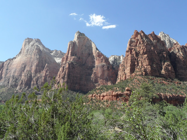
We decided to ride the shuttle bus around to get an overview--there's a pre-recorded tapeplay on the shuttle ride which has a lot of information about the history and geology of Zion, so we learned a lot.  We stopped at the Court of the Patriarchs for a short hike and a better view of some of the sights
The three Apostles 

It's beautiful here, but SO different from Bryce.  At Bryce, you start on top and hike down into the valley.  At Zion you start at the bottom and hike up.   It's much hotter here----close to 100 degrees was the high today, and it stayed pretty hot til around 2am---we got up several times in the night to cool off (Nils soaked in the river at midnight), to close doors, get a drink of water,  pull in the awning (very windy), gradually pull on more blankets....not a very restful night.

Final day in Bryce

Tuesday, 8/28

First thing this morning we picked up Tom and Bonnie at their nearby RV and began the Fairyland Loop walk.   Which sounds benign, but it's not.  It really does look like a fairyland of castles and towers--all in orange and white, as usual--but it involves a lot of climbing down and up and down and up again over a total of 800 feet of elevation change.  And it's 8 miles long.

I had to push hard to  keep up with Bonnie and Tom (and Nils) who are all in much better condition than I am......but I was the persistent caboose and didn't have to be left behind after all.
Tom and Bonnie, the speedy ones, with Lisa (the caboose)
Doesn't this look like an ancient Egyptian statue of a cat?!


Window on the left, bridge (crumbling!) on the right
My obsession with the twisty trees continues....aren't they amazing?!
PHOTO 06

More enchanting sights


Yay!  In celebration, we had a little party with Tom and Bonnie and recharged our batteries with crackers and cheese and peanut butter and chips and guacamole and lemonade. When we were out buying party food, we went to the ranger's desk to get our "I hiked the Hoodoos" buttons.  You have to show proof of having done the Fairyland hike, so we showed them this:
There's Lisa's sideways face by the official medallion--see, it says "I hiked the Hoodoos" along the bottom edge
But the very young ranger said that one also had to hike 4 miles, that the medallion we photographed was at the 3.4/4/6 mile mark depending on which way you hiked the loop.  Hmm.  Nils showed him our other Fairyland pictures as proof and he finally gave us our hard-earned badges.  Later on, we talked to some older rangers and told them this story.  They said, "I bet it was Sean.  He's kind of a Nazi about giving out those badges."  Anyway, we did the climbing and we earned our reward, that's for sure.    It felt good to sit around for a few hours after all that strenuous climbing.   Our solar panel is slowly charging up our ailing RV batteries which are still a source of aggravation.  We can keep the frig running and operate the pullout/jack/stabilizers, but that's about it (no water pump, no lights).  We've been going to the faucet close by to fill up our gallon jugs, and it's really not such a hardship.  I can wash myself (including hair) AND the dirty clothes from the day in just 1-1/2 gallons of water.

I was so beat after our big long walk that I fell into bed by 7:30pm and slept for 10 hours straight.

Monday, August 27, 2012

Day two in Bryce Canyon


Monday, 8/27

After making sure that our solar panel was in the full sun (we have been having mystifying battery difficulties lately and needed all the solar power we can get), we left for our walk around the Peek-a-Boo trail.  It sounds cutesy and benign, but it was neither.  Again, a series of switchbacks down and then up with jaw-dropping scenery and quite the cardio workout.  It was listed as a 3-4 hour hike, and we did it in 2 hours and 20 mins (we are Rock Stars!!!) even though we took many time-outs along the way for gawking and photographing (and catching our collective breath). 

Amazing vista through a natural archway
See the little window, way up high behind Nils?
The Wall of Windows
This reminds me of an army of Egyptian statues...the so-called Hoodoos

The paths were just plowed into the mountain side and of clay-sand…...I figured out that is what added to the ancient feel of the whole thing.   Everywhere you look are trees which have twisted into spiral patterns...no one is really sure why.   I took many pictures of them (yes,I'm obsessed.  It's a vortex thing), but this is the only one that really turned out:

A twisty tree
We came home to the RV and recovered from our exertions.  Nils also had to do some diagnosing of our current battery problems which have been perplexing and vexing and, well, a pain.  Turns out our neighbor, Tom,  a few sites over has a bunch of solar panels on his RV and is an expert on power issues.  He spent hours this afternoon helping Nils to fix our wiring issues, (including getting UNDER the RV to look at the wiring)....we are so grateful, and will be stopping in Flagstaff, AZ to get an additional solar panel and newer, better batteries, etc.   Then maybe we will have finally solved our power issues.   Tom and his wife Bonnie are going to join us on our hike tomorrow morning.

Time for bed---more tomorrow!


Auf Wiedersehen, Fruita, Hello Bryce Canyon


Sunday, 8/26

Finally the scenic drive just down the road from our Fruita campsite was open again (after being closed for 2 days due to rain and flash flooding) and we toured about 10 miles of it at sunrise this morning.  GORGEOUS!  The light wasn't really the best for photos but here are a few anyway…

"The Chimney"
The colors are much more vibrant in real life, red brown, greenish blue and white
Diagonal stripes---very modern looking

Temps in the low 60s, sunny, beautiful puffy clouds.  Then we hitched up the RV for the drive to Bryce Canyon.  We traveled through Dixie National Forest (I have to research why there's a Dixie anything so far from the Mason-Dixon line) and then the Grand Staircase-Escalante National Monument.  Very scenic, LONG vistas that just went on for miles and miles, of mountains and desolate sandy-looking desert.  We passed roads to Box-Death Hollow and Hells Back Bone along the way (they're both on the Utah map if you don't believe me).   Felt a little like being in a moonscape, or the bottom of the ocean.....so interesting to look at, but you'd die of exposure in about 12 minutes.  Speaking of Death, we narrowly avoided it many, many times.  As much as a 14% grade up and down and winding around narrow roads with no guard rails and the sheerest drop=offs on either side.  I got vertigo just looking down out of my window.  Nils was too busy trying to stay on the road to look down, or sideways or anything else.  It was stressful, to say the least.  But GORGEOUS!!!  Wow, what incredible scenery.  There was a literal wall of mountains that stretched for miles and miles and miles.  Supposedly there's a "hole in the rock" to which and then through which intrepid Mormon settlers managed to climb and slip and slide with their horses and wagons.  The Ute Indians didn't believe that it was possible and thought the Mormons were just liars with Pantalones del Fuego.  But they did it.  The town of Escalante was obviously Mormon...the main drag was at least 6 lanes wide!  The woman ahead of us at the gas station had ridden her lawn mower to the station for a fill-up.  That's how busy the street was on this lazy Sunday morning.  Beautiful irrigated green fields, horses and cows.    

We arrived at Bryce Canyon at 11:30am and quickly found a camping site.  Then took off for a little sightseeing drive to the major lookouts.  Wow! 

PHOTOS 24, 31 42
It looks even more orange in real life
Doesn't this look like masses of cathedrals with weird flying buttresses?
That's svelter Lisa in the foreground, Hoodoos in the background (and the Escalante/Grand Staircase in the WAY background)

It's an even deeper orange than in the photos.  Just spectacular.  We got to the visitor's center just as the skies opened up.  Thunder!  Lightning!  Hail, even!  Temps dropped about 15 degrees within 25 minutes.  And then it was over.  According to everyone, this happens most afternoons.  We came home, started a puzzle and then decided we had do at least an easy hike between Sunrise and Sunset Points (about a mile).  BUT we were mesmerized by the series of endless switchbacks down and down and down, and couldn't resist following the other hikers about 700 feet down to the floor of the canyon.  MAGICAL.  Also strenuous.  It felt like being in an ancient Moorish mountain=side village.  Everything was orange, with narrow winding paths, walls and doorways all with the feel of unfired clay.  It was like a walking a labyrinth in a sacred space.

That's Thor's Hammer to the left and the Three Ladies slightly behind and to the right
We switchbacked all the way down to the bottom, where the people look like ants. 
Wow!  It was hard work climbing all the way back up again and totally worth it.  Can't wait for our hike tomorrow morning!

PS from Capitol Reef


A few more notes  about yesterday before we say good-by to this surprising, beautiful hidden-away place.  First of all, thanks for your patience, blog-followers, during our one-week absence.  In these gorgeous mountains, wi-fi access is hard to come by.  We spent 45 mins in the parking lot of a Best Western on Saturday afternoon downloading pictures which used up so much bandwidth that we couldn’t do email or anything else during that time, THAT's how dedicated we are.  

All along our Sulfur Creek walk yesterday morning, my eye was caught by peach-colored stones.  Everywhere!  So I loaded my pocket with a handful of them.  Sort of like finding all that mica glittering at Sylvan Lake, so long ago.  They almost don't look real, they're such a pretty color, but you saw in the photos that some of the geology really IS that color.  

After our successful wi-fi session, we took a little drive through the town of Torrey, which was also settled by Mormons….it certainly had a wide main street.  I spotted a little store called the Robber's Roost which was a bookstore/espresso bar/gift shop and had a crunchy, promising look to it.  I saw a sign advertising a Farmer's Market, but assumed it would already be over and done, as it was approaching 4pm.  Well guess what?!  It STARTED at 4pm!!   We bought freshly made pesto, and OG zucchini and cauliflower and kale and cucumbers, goat's milk yogurt and the best sweet little tomatoes.   There were also cinnamon rolls and still-warm loaves of sourdough bread for the gathering throngs.  Thankful and excited for dinner, we came home and I cooked some really good food: ribbons of sauteed zucchini topped with a sauce of tofu, onion, mushroom, fire-roasted tomatoes and a lot of pesto, of course.  Cucumber-tomato salad and peaches for dessert of course. 

So now, to summarize all the great things about Capitol Reef and Fruita campground:

  • Spectacular, jaw-droppingly beautiful and variegated scenery
  • Free peaches, pears and apples to eat fresh off the tree
  • Six kinds each of scones, pies and breads baked fresh daily and avail 25 feet from our RV.  And homemade ice cream.
  • Oh, and it's not humid at all.
  • And the sky is hardly cloudy all day.
Doesn’t that all sound amazing?  It truly was. 

View from our RV
Say, have I mentioned all the Germans?!?!?  Seems as though 2/3rds of the campers here are German tourists.  I can spot them at 20 paces just by their shoes (seriously) It's been fun talking to them.  These days, when we encounter someone along the path we immediately say, "Guten Tag".  It's just easier that way.

Saturday, August 25, 2012

Second day in beautiful Fruita


Saturday 8/25

I continue to read more about Mormons in the 1800s.  Wow, what a story.  You just can't make this stuff up.  One has to admire their determination, industry, organization and taming/beautifying of some of the most God=forsaken unpromising land in the whole United States.  And then on the other hand, the strange prophecies, the slavish devotion to autocratic religious leaders, the belief that the City of Zion (somewhere in Missouri, I think) will be lifted into Heaven someday to the special Mormon celestial exclusive heaven (everyone else relegated to lower echelons of heaven, or worse yet--hell)….a little hard to swallow.  Not to mention the secret special underwear that you're never supposed to completely take off (it fortunately has not proven an impediment to Mormon procreation).  I'm finding it fascinating (and a little creepy). 

Our big hike today was along Sulfur Creek, in a deep canyon.  Because of the recent rain and flash flooding, it was QUITE muddy and wet.  We had to cross the creek many times over rocks and sand.  It was usually not very deep, but deep enough, in any case, to soak one of my boots.  We encountered a lot of Saturday morning hikers along the way, including a Mormon girl's youth group who did a lot of shrieking in the muddy places.  Fortunately we were able to pass them quickly.

Again, the scenery was breathtaking and ever-changing.  Here are some pictures that give at least a flavor of what we saw:

starting our hike

More crumbling splendor
closeup of some suspended animation waves


in Mormon Country


Friday 8/24

First thing this morning, I felt the clarion call of those scones and presented myself at the shop at about 8:05 to consider the vast selection and make my choice.  I finally settled on a peach scone and ate half of it in celebration (but hopefully not a sabotage) of weighing my lowest in about 20 years this am.  Between the two of us, Nils and I have lost 55 pounds in the last 1 1/2 years. We are both extremely proud of ourselves.

Then, properly fueled, we walked the Cohab Canyon Trail and back, then walked to the Hickman Bridge (a natural stone arch).  Breathtaking!  The pictures just don't come close to conveying how beautiful it is, but here they are anyway.  Because we were such early birds, it was cool and breezy AND we had it pretty much to ourselves, which is (as you've gathered) the way we like it.  I realized, from my Mormon reading that "Cohab" is short for "cohabitation", i.e. polygamy.  Really (this is Lisa the Anthropology major speaking here), it should really be referred to as polygyny, because in the land of Mormons we're always talking about one man with a multitude of women.  Just in case you were wondering. 

Nils in a section carved out by water, long ago
It's really spectacular

There were all these cool slot canyons along the way---a rock climber's delight.  It was so beautiful, it really resembled an enormous art studio---full of color and texture and discarded attempts and flowing design.  Just spectacular.  By the time we got to Hickman Bridge, it was close to noon and quite hot.

Nils's great photo of the Hickman Bridge

Before arriving back at the RV for some well-deserved sluicing off, we stopped at one of the open orchards and picked peaches and ate right off of the tree.  They were SO delicious!  You're encouraged to eat as much as you want for free...any fruit you carry out with you costs the princely sum of $1 per pound, all on the honor system.  We brought back a pound in my hat, and about 3 pounds in our stomachs, collectively! 

After our showers and a little rest, we rode our bikes to a different orchard which had pears.  But they were nowhere as good as the peas, so after trying one, we got right back on our bikes and rode to the juicy peaches.  If I were close to home, I'd be baking peach crumble right now.  It reminded me of making peach jam with my mom and coating the whole kitchen in a film of stickiness.  Delicious on homemade bread.

This place is so beautiful that we're staying another night--time for another hike in the morning!

on our way to Capitol Reef


Thursday 8/23

We departed from our campsite at the crack of dawn because we had a long driving day ahead of us.  Passed a gaggle of wild turkeys strolling along the side of the road.  Also families of deer and a few bunnies.  More up and down driving through amazing scenery.  Utah is gorgeous!  Layers upon layers of color and texture, constantly changing.  So often the natural erosion ends up looking like crumbling bricks and mortar--I have to keep reminding myself that it is NOT man-made.  We passed coal mines, coal-fired power plants, cattle ranches, lots of irrigated fields, otherwise everything was brown/yellow/red.  We stopped at a hopeful little town along the way, with its requisite LDS (Latter Day Saints) church.  We were thrilled to note that even the side streets were incredibly (almost weirdly) wide--enough that Nils could easily do a U-turn with our 20 foot trailer, in one wide curve.   Turns out that Mormon-designed town layouts always have very wide streets (I read later, with great interest, from Wallace Stegner's early book Mormon Country).  I also read that Kirtland, Ohio was a Mormon town originally….we're curious to see it, possibly, on our way back east. 

Anyway, we drove and drove and drove.  At 1:20pm it was only 55 degrees F as we crossed over high mountains (in a drizzle) in the Fishlake National Forest.  The clouds looked like smoke tendrils hanging in the mountain tops, sort of like the Great Smoky Mts of Tennessee.  The landscape kept changing and got more and more beautiful, esp as we were entering Capitol Reef.  Wow!  This place really seems to be giving Flaming Gorge some serious competition.

We arrived at the Fruita campground by around 3pm.  From the door of the RV we could see a little mule deer grazing,

A deer little visitor

as well as two horses in an adjoining field.  Also could hear water flowing in the nearby little river.   This tiny valley was settled by Mormons in the 1880s.  They planted many orchards of fruit trees (hence the name, "Fruita", pronounced "froo-ee-ta").  There are a few old museum buildings, one of which is just on the other side of the horse field.  It sells 6 kinds of scones, 4 kinds of bread and about 5 kinds of fruit pies, baked daily and available starting at 8am.  Pretty fantastic.  Nils bought a small round loaf and ate practically the whole thing in one sitting.  I indulged in a small cup of homemade chocolate ice cream, and was supremely happy.

Kayaking on Flaming Gorge


Wednesday 8/22

Woke to very overcast, dark-grey skies for our planned kayak day.  :-(  Even some sprinkling of raindrops.  Well, at least it was cool out.  By 10am we decided to risk it.  What a great time we had, with the gorge pretty much all to ourselves.  Flaming Gorge is flaming gorgeous (I can't be the first one to coin that phrase, either).  We saw grey herons, hawks, fish jumping and wild turkeys along the road, on our way to the boat launch.  And then we were surrounded by amazing geology….striped white, pink and red stone in a state of crumbling, ueber slow motion decay.  It's surreal when human time scale sits for a moment, contemplatively, in geological/earth/universal time….the human time frame is  just the wink of a wink of an eye by comparison.  It's bizarre to wrap one's head around that.  Also very relaxing and peaceful in a way….the whole notion of rushing and stressing out seem absurd.

See the profile in the rocks?

You can sort of tell that the rocks are reddish in the background
Mama and Papa birds next to their big nest

We were on the water for at least 3 hours, exploring little side canyons,  and just generally gawking at the whole spectacle.  Unlike our previous attempt at canyon kayaking, the water was calm, the temp was pleasant and not too windy, and there was only enough rain at the beginning to ensure that we had it all to ourselves.  Brilliant!

On our way to Flaming Gorge


Tuesday 8/21

On our way to Flaming Gorge...through some big Wyoming towns which clearly do booming business in skiing/fishing/boating/hunting/taxidermy tourism.  In Pinedale, I saw two small flocks of geese flying overhead...must have been traveling to the lake nearby.  Always a good omen for me. 

The drive into the Gorge was "exciting"---lots of ups and downs at very steep angles, no guardrails and constant & close proximity to death.  Poor Nils!  It was pretty stressful for him.  We made it, though, and found THE best spot on Mustang Ridge (#43)...we have a view overlooking the Reservoir and we can walk into the red rocks which descend to the water's edge. Just gorgeous.

View from our campsite into the reservoir at Flaming Gorge

After our early dinner we went for a little cooling swim at the nearby "beach" which was very refreshing.  We KNEW there was a reason that we brought swim noodles with us all the way from Deerfield!  Later, after a nap, we checked out the boat launch for tomorrow's planned kayaking.   It was hot til evening but then cooled down quickly.  We feel as though we're practically the only ones here right now.  The camp host told us that come Thursday it would totally fill up again.

near Jackson, WY on the Hoback River


Monday, 8/20

 Correction---our lovely campsite is on the Hoback River (which flows into the Snake River).  It's quiet and lovely here….we have great views in all directions and a cold river for taking a dip when necessary (for Nils.  Too cold for me)

View of the Hoback River from our campsite

We returned to Jackson to the fantastic grocery store for a few extra things that we forgot, also visited the Jackson library, which had preferential parking places for hybrid cars!  Not even Northampton MA has that yet.  We were impressed.   Our cashier at the grocery store said that the lefties and the Tea-party-ers all seem to coexist well in Jackson.   Sounds like a great place to live.

Monday, August 20, 2012

Hiking around Jenny Lake in the Tetons


Sunday 8/19

We are the king and queen of flexibility: we had planned to stay 5 nights in the Tetons, but we're leaving this morning early.  But, before leaving completely, we decided to hike around Jenny Lake which has fantastic views of the Tetons along the way.  This was no trivial hike---about 9 miles all together.  It's one of the most popular hikes in the park, so even though we started at 8:45am, we had a fair amount of company.  A whole bunch of people boarded the ferry to avoid so much walking which made hiking nicer for us.  We took the optional climb up to Inspiration point (almost a 1/2 mile up and then back again) which was lovely, overlooking the Cascade Falls.  Everything was so green along the way----miles of lush thimbleberry bramble overflowing onto the path (like flattened-out, tart raspberries), along with sage brush and every size of pine tree imaginable, from 18" Christmas tree wannabes to hundreds-of-feet tall lodge pole pines and everything in between.  One of the low shrubs smelled like cinnamon….between the pine and the cinnamon, I was flooded with thoughts of Christmas, and all the things I'm going to bake when we're together with my family in Florida this coming December. 

Nils at the base of Cascade Falls

Of course someone felt inspired to make an important-sounding business call from his cellphone and then send a text from up there.  On a Sunday?!  Surrounded by all that splendor?  He really couldn't think of ANYthing better to do in that gorgeous spot?   Sigh.  We came down from the point of inspiration and kept walking around the lake for the next, oh, 3 hours.  Saw only a handful of equally intrepid hikers.  (the less hardy---or should I say foolhardy?!--just took the ferry right back to the starting point.

About 2/3rds of the way around, and still smiling....

I was too tired to smile much more by the end of 4 hours, 18 mins and 27.49 seconds on the trail.  We were plumb tuckered and could have done without the final mile and a half even though it was all beautiful.

We got to the now-crowded parking lot and hoisted our tired selves into the truck---we were on our way to Jackson, and the Jackson Whole Grocery store.  Wow!!!  It was fantastic and huge, like going to Whole Foods.  We stocked up big time and spent over $200.  Because we parked around the corner from the store (it's not so easy finding parking when you are hauling a 28 foot trailer behind a big truck) we had to carry everything about 1/4 mile.  Or at least it felt that way.  Only the incentive of great food kept me going at that point. 

We were not sure where we were going to camp for the night….only that we wanted to be on the way to Flaming Gorge.  We saw some camping places on our way out of Jackson, but they were too crowded and/or too expensive.  Then, out of nowhere came that most welcome of signs, "Camping 1/2 mile".  It was a sign put up by the National Park Service and when we turned into the unassuming little road, we found ourselves right on the Snake River with a view of the mountains behind us.  For $15/night!  It was a little hot at our campsite so Nils immediately undertook a cooling dip in the river.  It was so shallow and so VERY cold that he waded out calf deep, put his hands down on the rocks about 2 feet in front of him and then gathered up the fortitude to lower the rest of himself (into a push-up) for about a half second in the freezing water.  That was enough to  cool him off pretty fast, but the effect was temporary.  On his second cool-off venture, I walked down to the river too--it's only about 20 feet away-- with the long-handled bath brush and stood in about 5 inches of numbing water to scrub our hike off of my feet and legs...the dust from the trail actually made its way through the mesh of my boots, through my thick socks and onto my feet.  I was a mess from mid-calf down.  To wash the rest of me I used warm water in the RV….I'm not a big fan of ice cold bathing, unless it's over 95 degrees out and I'm totally over-heated.   

I made a gourmet feast with fresh cactus leaf, tacos, avocado and a green salad with roasted curried cashews (which I roasted and curried myself) and sliced apple and fresh cherries in it.   YUM.  Should have taken a picture of THAT!   I may just have to write an RV cookbook for vegetarians.

We started a puzzle (of the Tetons, appropriately enough) and had a relaxing evening in a gorgeous spot.  We will probably stay here another night, which means we can go back into Jackson for anything else we've forgotten.  

Kayaking in the Tetons


Saturday, 8/18

Wasn't sure first thing this morning whether we'd have good visibility, but by late morning a lot of the mist had burned off or lifted or whatever it had to do.  We decided to do some kayaking on Jenny Lake but since it was close to noon by the time we got there, and it was a Saturday, the parking lot was packed full and overflowing.  So we went to nearby and smaller Leigh Lake instead, where parking was not as impossible.  Leigh Lake was named after Richard "Beaver Dick" Leigh.   He probably had to run away from home to become a beaver trapper Out West, because with a nickname like that, what other choice do you really have?
Lisa with Tetons in the background...see how clear the water is?

The water was crystal clear and we had great views of the Tetons with glaciers and snow on top.  Lazy-ish and fun.  We decided to take a longer loop home to see more of the park.

Us, in the wind, photographed by the nice Virginian

Met a really nice couple from Virginia who had retired early and were on a 2 month trip out west.  They were doing a reverse route of ours, so we were able to tell them about some things to be sure not to miss.  We've gotten great suggestions from fellow travelers as well. 

Because we have electrical hook-up at our site, we were able to watch some more West Wing episodes and I even got some applique-ing done on my project.  I had originally thought that I'd be burning through the handwork projects, but a) we're busy during the day with hiking and exploring, b) we're busy in the evening either watching West Wings OR updating the blog (it takes time to crank out quality like this, people) and c) when we're driving, it's WAY too bumpy on the concrete highways for me to do anything other than look at a map and hold on tight.  I tried crocheting lace in the truck when we first left Ohio, with a teensy sharp crochet hook and white thread.  It was a laughable proposition (not to mention a little dangerous).